
DRUID ARCH LOOP
Canyonlands Natl. Park (Needles District), Utah
Length: 19mi (30.6km)
Days: 2-3
Difficulty: Medium (clear trails and manageable distance, but rough terrain involving ladders and some climbing)
Gear: Standard gear + WAG bags
Completed: September 2021
In summary: Druid Arch Loop stands amongst some of the best hiking that Utah has to offer and should be a bucket list trip for any weekend warrior or aspiring canyoneer. Wandering the exotic “needles” (most look more like mushrooms in my opinion), various arches, and desert landscapes makes for a unforgettable hike. The need to climb ladders, squeeze through tunnels and clamber over rocks on all fours only adds to the excitement. Exploring “The Needles” is undoubtedly a choose your own adventure type of trip, but no matter how you set your itinerary, do not skip the magnificent Druid Arch. The arch can be reached in a long day’s hike, but why not take some extra time to camp, soak in this beautiful place, and capitalize on its status as an international dark sky park?
Preparation / Know Before You Go
Permits are required: To minimize the environmental impact imposed by backpackers, Canyonlands runs a strict permitting process for all backcountry sites. Prospective hikers will need to obtain a Recreation.gov permit in advance of their trip to secure their desired itinerary.
Build your own route: That’s right, there is no clear overnight trail or established route that is recommended to backpackers in the Needles District of Canyonlands. Rather, you will have to chart your own course based on the messy web of trails available in the area.
WAG bags are required: WAG, or “waste alleviation and gelling”, bags are intended to reduce the damage caused on an environment by human waste and are required of overnighters in Canyonlands Natl. Park. This may seem like a hassle, and admittedly it provided me with more than enough incentive to “hold it”, but the policy does have its benefits. Surely many of you have come across ugly caches of toilet paper and waste when backpacking, and this requirement prevents this in a dry environment where waste could take years to decompose.
Stay on the trail: This should go without saying, but staying on trail is especially important in southern Utah’s desert landscapes due to the presence of fragile biological soil crusts. These crusts, made up of living microbes, are critical to a functioning ecosystem in this harsh climate and a single errant footstep can destroy over 50 years of growth.
Be flash flood aware: World class canyoneering comes with its risks, so it is best to be mindful of these and take appropriate precautions. Check with a ranger before departing and NEVER camp in the floodplains outside of established sites. Remember, flash floods can occur even when no rain is present.
Day One: Squaw Flat to Campsite EC1 via Squaw Canyon (6.6mi.)
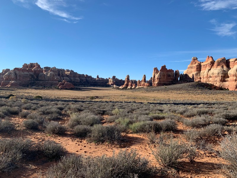
Standing in the Squaw Flat parking lot, deep within “The Needles District” of Canyonlands National Park, one can’t help but take in the desert beauty all around. The land is relatively flat, and pristine landscapes stretch as far as the eye can see, leading all the way to a dramatic vista of the La Sal Mountains 30 miles east. Despite this beauty, it isn’t immediately clear from the trailhead how this famous national park earned its iconic name. Rather than the deep sandstone canyons that adorn postcards and travel websites, the defining topographical feature of the park appears to be towering, crumbling buttes. Nonetheless, we embarked on our journey across the desert, following a flat dirt path that stretched into the expanse. As we walked, we took note of the sharp, weathered texture of our surroundings, indicative of the harsh realities of life in the high desert. The trees were gnarled and dry, the cacti prickly, even the dirt was wrinkled and brittle, formed into microbial soil crusts that had coalesced over decades to cope with the severe climate.
Steadily, as we moved along the path, we observed as a small orange crest on the horizon grew into a colorful wall of layered sandstone. We posited that that we had finally reached the eponymous canyons, 2.5 miles in, though it was entirely unclear how we were going to enter them. The trail appeared to be leading us straight towards a never-ending wall. We put our trust in the map, however, and after a bit more walking we reached the base, where a small crease in the stone brought us gradually up the steep sides of the cliff. Just when we thought we couldn’t safely climb any further, we were redirected towards a small fissure in the rock wall, no more than a couple feet wide. To cram through seemed absurd, but a log jammed into the crevice, seemingly to prevent a 127 Hours situation, had footprints on it that suggested it was possible.
After my first attempt at squeezing through the crevice was rebuffed, I had to rearrange my pack and give it another shot. This time I slipped through and was able to enter a narrow tunnel in the rock. The other entrance glowed orange in the late afternoon sun, and when we emerged from the darkness it was as if we had entered a whole different world. There we were, in the heart of the vast Squaw Canyon, blown away by the vibrant mix of colors and intense scenery around us. The canyon was deep, with multiple levels and interesting rock formations in all directions. After scampering down a log positioned as a ladder, we found ourselves walking atop the canyons second level. Both gazing down into the dried up wash below and gazing up at the prominent peaks above.
Perhaps 30 minutes after the challenge of squeezing through the tunnel, we were faced with our second exciting obstacle of the day: a metal ladder that would permit us to jump between canyons. Emma was a little anxious to test the ladder with a loaded backpack as counterweight, but my past experience on the Drakensburg Grand Traverse had prepared me well. This ladder was much shorter, and undoubtedly more secure. After conquering the ladder without an issue, we found ourselves on a smooth sandstone saddle with panoramic views of the Squaw Canyon and Elephant Canyon juncture. I cannot say that I have ever been in a natural place with more detail geologically, so we took a quick pit stop to grab water and snap photos. By this time, we were not far from our intended campsite in Elephant Canyon.
Following our break, the remainder of our journey was quite straightforward, but equally enjoyable. A similar ladder on the opposite side of the saddle dropped us officially into Elephant Canyon, where we caught a short set of switchbacks that took us to the labyrinth’s floor. After about two and a half miles winding along the canyon’s sandy bottom, we reached our campsite. I couldn’t have dreamt of a better location for our one evening in the backcountry as the hilltop site epitomized Canyonlands. A perfect sitting boulder served as our kitchen and dining room while we admired the sunset and soaked in an all-encompassing view of the distinctive spires and hoodoos that give The Needles its name. We both agreed, however, that the blunter, more rotund spires that filled Elephant Canyon were more akin to ‘mushrooms’ than ‘needles’.
When it was finally time to turn in, we decided to capitalize on what was projected to be a warm night by leaving the rainfly off our tent. Park rangers had educated us about Canyonland’s status as an International Dark Sky Park, and we wanted to see what the hype was about. It did not disappoint. Though bone tired, I spent at least an hour of the evening basking in the soft blue glow of the Milky Way. When I woke up restlessly, halfway through the night, the display was even better.

The entrance to Squaw Canyon from near the trailhead 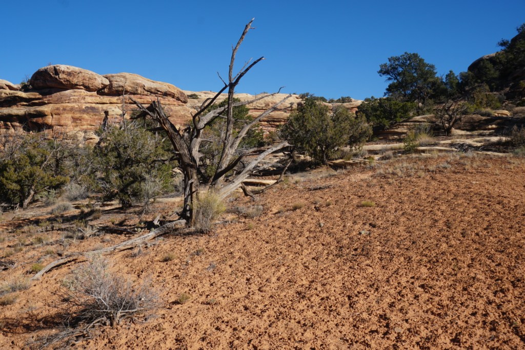
A large patch of the delicate biological soil crust 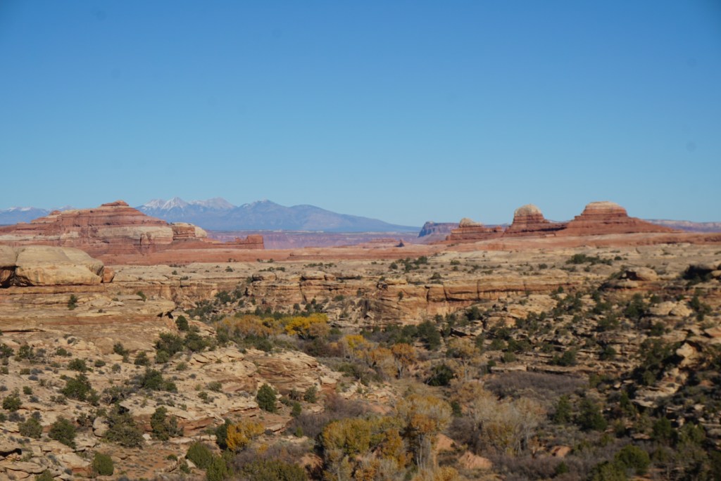
The distant La Sal mountains from Squaw Canyon 
A very tight squeeze on the trail 
Out on the other side of the tunnel 
A pass from Squaw Canyon to Elephant Canyon 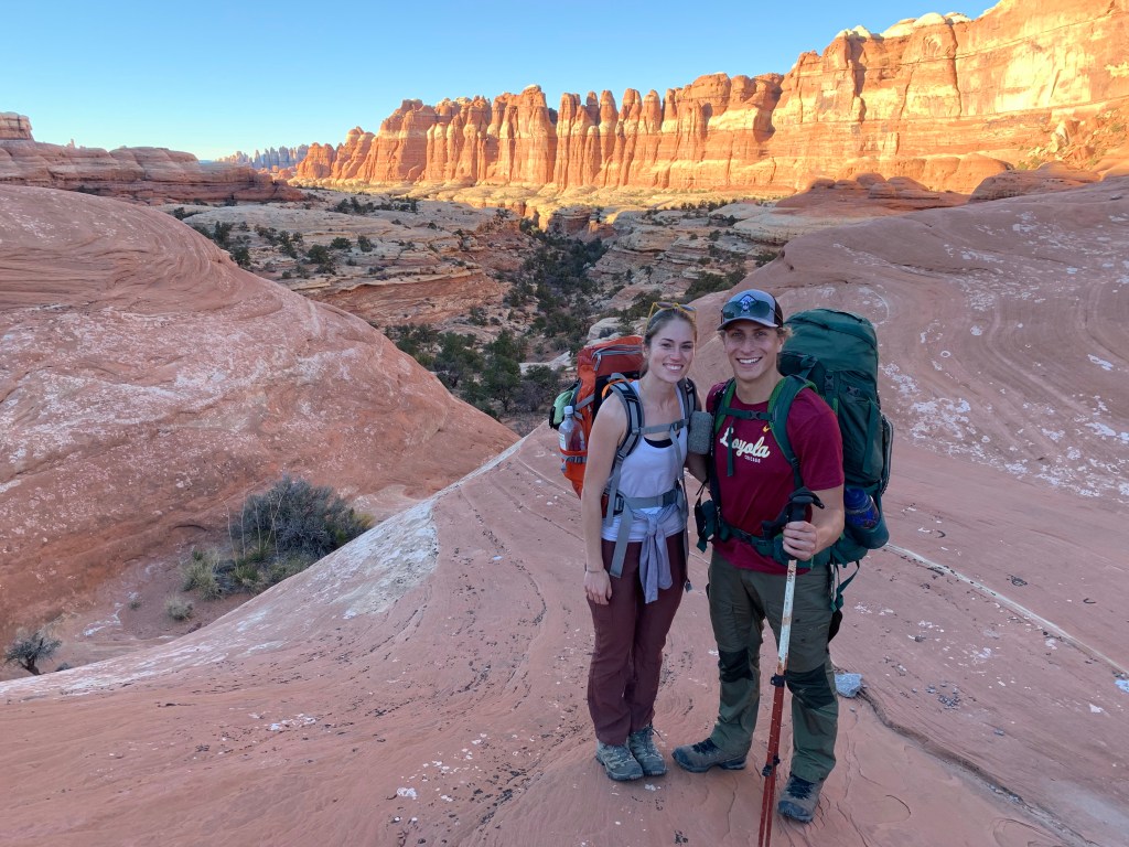
Elephant Canyon in the late afternoon glow 
More obstacles on the trail 
Elephant canyon 
A beautiful, private campsite (EC1)
Day Two: Campsite EC1 to Squaw Flat via Druid Arch (12.4mi.)
Determined to buck our trend of later than desired starts on backpacking trips, Emma and I woke up early to begin our long second day on the trail. Fortunately, the trail supported our efforts by immediately sending us on a warmup climb into a new section of the park where we were treated with wonderful views. In a flash, Elephant Canyon had disappeared, and we were walking atop a mesa with panoramic views of the vast Colorado Plateau.
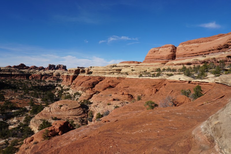
Just as there are various layers to Canyonland’s famous sandstone formations, we found there to be multiple layers to the hiking in the Needles, and by traversing the Druid Arch Loop were experiencing them all. No more than a quarter mile from our campsite, which had been tucked deep within the maze of canyons, we were now thoroughly immersed in the second layer. Ahead, we were faced with a great wall of thin sandstone, while just behind, we marveled at the curved domes of what appeared to be a plethora of mammoth mushrooms. What had once towered above us, now formed a false floor, obscuring the deep canyons below us in layer one. Perspective had certainly changed.
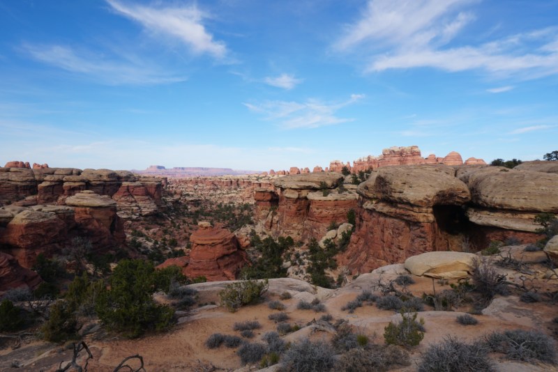
After another half mile or so of walking, we came to a small divide in the large sandstone wall where we crossed the threshold into the well-known Chesler Park. Once again, the space changed, opening into a beautiful sage steppe that resembled a natural amphitheater. The stage was wide and flat save for a few low ripples, while towering hoodoos and textured walls formidably boxed in 90% of the park. The small bit that wasn’t enclosed stretched endlessly away from the loop trail and into the horizon.
In addition to being integral to the scenery, the gentle grades of Chesler Park served as a respite from the steep climbs and backcountry ladders that allowed us to shave off a mile and a half from the day in no time. We used a few of these extra minutes to check out the Chesler Park campsites, where we were told that there was an archeological site worth exploring. The detour was short and definitely worth it. Barbed wire, rusted cans, bullets and inert dynamite combined with hundred year old graffiti served as a reminder that early settlers and gold prospectors had also frequented this beautiful place in search of wealth and a fresh start. As a fair warning to those who may hike with children, some of the sandstone graffiti is quite explicit.
Had we been camping in Chesler Park, I would have loved to poke around the ghost settlement for longer, but we had a schedule to keep to, and thus our stop was short-lived. After putting our packs back on and completing a quick jaunt back across the park, we were led once again into the mushroom forest. This short section turned out to be one of the most challenging parts of the trek. Prior to arriving at the Druid Arch junction, we weaved our way around and through a series of nameless capillary canyons trying to navigate our way back to the main vein. It was narrow, steep, rocky, and hot, but we eventually emerged in Elephant Canyon triumphant.
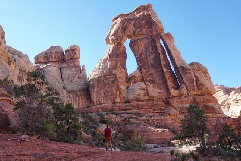
Facing a 1.6mi. one-way trip to Druid Arch, we decided it would be shrewd to abandon our heavy backpacks, so we did, stashing them under the cover of a few dense bushes nearby. Water and lunch in hand, we began an arduous climb up the wash and towards the canyon’s terminus. The entire way, two reflections stood out to me. One, how blessed we were to be able to experience this wonderful, protected piece of public land on a balmy fall day. And two, how smart we were to have left our packs behind. After the second time scaling the face a dry waterfall on all fours, I began to crave lunch and a resting place at the end of the fork. Even upon arrival at what appeared to be the back of Elephant Canyon, there was no arch to be seen. Here, we also ran into another confused couple, who had arrived 10 minutes earlier and were almost certain they had gotten lost. Puzzled, we poked around for a few minutes before I noticed a small path that appeared to run straight up the rocky cliff of the canyon. With no better alternative, I tried following it. A couple switchbacks into my scamper, I located a rock cairn, indicating we were on the right path. I called out and our new hiking party followed. Ten minutes later, we reached the top of a massive ledge, invisible from the canyon floor, where we stood collectively transfixed.
Despite completing a three day trip to Arches National Park just two days prior to our Canyonlands trek, Druid Arch instantly became my favorite geologic formation in Utah. For starters, the sheer scale of the double arch is incredible. At 150ft. tall, it resembled to me the AT-AT walkers from Star Wars. To add to the magnificence, the arch stared down an incredible view of Elephant Canyon from the upper levels. It was the perfect spot for a break, so we took a long lunch, soaking up the sun and admiring the colorful sandstone strata the entire time.
Reluctantly, after a wonderful morning of trekking, it was time for us to begin our journey back to the trailhead. So, we gathered our things, left the arch, recovered our packs, and followed a new path out via Elephant Canyon. While the proceeding 6.7 miles felt much like 12.3 miles prior, it would be erroneous to describe anything in The Needles as ‘more of the same’. Each winding turn and laborious climb brought with it a new vantage point, interesting landscape, or incomparable sandstone feature. Without suffering a dull moment, we finally emerged back onto the high plateau from which we had started. A cool breeze and refreshed vista of the La Sal Mountains greeted us upon arrival as welcome gifts to commemorate our journey.


3 Comments